"Very High Risk" of Hurricane This Year? Here's the Brooklyn Map
 Is it just Gowanus Lounge or was there an unnerving, ho-hum reaction to this week's prediction that New York City is at “very high risk” of a hurricane this year? In point of fact, because of weather patterns, the New York metro area literally has a big red circle over it.
 No space here to go into a long and exquisitely detailed discussions of the potential consequences of a hurricane hit on New York (or of our own neuroses). Suffice to say that a National Weather Service meteorologist called the consequences of a strike by a Category 2 storm "disastrous." (Think serious flooding from storm surge, hundreds of thousands in evacuation shelters, submerged subways that will make December's strike look like a picnic, significant property damage, no water, no electricity, no ATMs, no Fresh Direct, etc.)
An excellent article in the Downtown Express summarizes some of the impacts and the city's new evacuation plans. Specifics are also available at the Office of Emergency Management's website. The city is planning on 500 shelters to hold 600,000 people and evacuation of up to 2.5 million. (Subletting opportunities galore!)
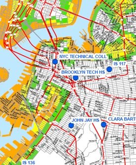
In the OEM map above, Orange areas would flood in a hurricane of any magnitude, Yellow areas in a Category 2 and Green in a Category 3 or 4. The uncolored areas are safe, from storm surge, anyway. (Upside: The Red Hook Ikea floats away with even a baby hurricane. Downside: All of Red Hook floats away.)
Still not picking up an inflatable raft and hip waders, packing a "go bag" and planning to stock up on bottled water? Consider the list of monster storms that have hit New York offered by climate.org:
· The Hurricane of 1821, which produced a sea level rise of up to 13 feet (about 4 meters) in one hour in the area that is now Battery Park City.The West Indian Monster of 1893, huh? Gowanus Lounge, who bought a wind-up radio last year, takes no pleasure in noting that hurricane season starts in three weeks.
· The West Indian Monster of 1893, which triggered a 30-foot (about 9-meter) storm surge that razed nearly all man-made structures on its course through southern Brooklyn and Queens.
· The 1938 Long Island Express and its accompanying tidal surge and surf, which registered on seismographs in Alaska when it roared ashore at Bayport, Long Island, causing 690 deaths across the Northeast. (This is the one that created the Shinnecock Inlet in the Hamptons.)
posted by rsguskind at 1:00 PM
![]()
![]()

2 Comments:
Recent hurricans like 1985's Gloria, 1972's Agnus and even 1954's Hazel have missed NYC, but the tail of the 1938 Hurrican touched on the city, brought a 30 foot tidal wave, ripped out more than 3000 street trees, and caused 600 deaths along the east coast.
The City's emergency management plan was to send 200 rowboats from Central Park out to recuse in the flooded districts.
In 1903 a rain storm dropped more a foot of rain in 24 hours turning streets into canals everywhere.
When the Gowanus floods, what will we be flooded with? Will we be seeing the seniors from Mary Star of the Sea on tv in any better cirumstances then the Katrina seniors laying in airports?
Anyone who has been a lifelong Brooklyn,N.Y. resident knows any evecuation out of the city or to any shelter area would be an exercise in futility and extremely dangerous. flooded subway at Nostrand and Flatbush, rampaging thugs ( this was kept under wraps in N.O.)in the neighboorhoods, and over whelmed emergency response. best keep the go bag with you at home, lock and load and hope for the best. survival in your own home is far better then on the street.
Post a Comment
<< Home