The Amazing Underwater Borough
We admit that we're a bit overly focused on what could happen to Brooklyn, and all of New York City, in a hurricane. But did you look closely at the Office of Emergency Management's hurricane evacuation map when the revised version came out last week? If you did, you will have noticed exactly how much of Brooklyn will be underwater in the (admittedly unlikely) event of a monster hurricane. But still, it looks like about one-third of our fair borough will look a lot like the Lower Ninth Ward of New Orleans.
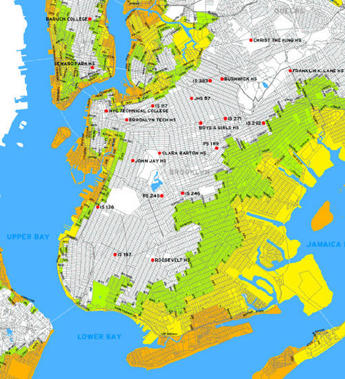
And we're not talking about under a little bit of water. Storm surges could be up to 30 feet in some parts of the borough. That's about three stories worth of water. You will note on the map below that all of Manhattan south of Canal Street in under water.
A snippet of the map is below. Orange areas get nailed in any sort of hurricane. Yellow in a Category Two and Green (the really scary stuff) in a Category 3 or 4. If a Category 5 strikes New York, we suppose that we become a part of the history books under Global Warming and that future generations in the desert around Minneapolis will read about what happened to us and shake their heads.
Now, those of you that aren't interested in things more than 24-48 hours old probably won't want to click on this next link, but if you want to read a riveting account of what a hurricane will do to New York, you should check out Aaron Naparstek's superb article in the New York Press in July 05. The devastation that Naparstek outlines makes could make New Orleans look like minor, if only because the scope of the flooding in New York will be so much larger.
posted by rsguskind at 11:00 AM
![]()
![]()

0 Comments:
Post a Comment
<< Home