Brooklyn Bridge Park, Part III: Where the Tall Buildings Will Go
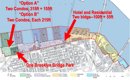
There are two main condo options according to revised plan issued by the Empire State Development Corp. Option One includes a building 315 feet in height with up to 290 condo and a building of 155 feet with up to 140 condos. Option Two includes two buildings of 215 feet, each with 190 units. There would also be a 170-foot building with 130 units north of the Manhattan Bridge.
You can check out the entire revised plan here at the Empire State Development Corp.'s website. Just click on "Modified General Project Plan" in the upper right hand corner for the PDF.
Related Post:
Brooklyn Bridge Park, Part II: The Sweetheart Deal Building
posted by rsguskind at 7:46 AM
![]()
![]()

0 Comments:
Post a Comment
<< Home