From Where Might the Roebling Oil Have Come?
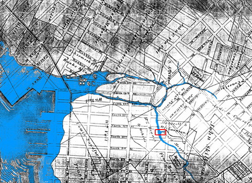
We have always believed that the oil oozing from the ground at the Roebling Oil Field at N. 11th Street and Roebling in Williamsburg was emanating from a ruptured tank nearby that can be found on environmental maps of the neighborhood. Workers have also noted digging up an oil tank on the site. Yet, the new blog Brooklyn 11211 has done some absolutely brilliant historical research and noted conditions that could be moving oil underground from other locations in Williamsburg to the site. It turns out old creeks that ran through the neighborhood ran directly through the Roebling Oil Field site (AKA McCarren Park Mews). The map above shows the original creek called Norman Kill, which was later renamed Bushwick Creek. The Roebling Field is in the red square on the map. Brooklyn 11211 writes:
So what does all this ancient history have to do with the discovery of oil on Roebling Street? Maybe nothing, but maybe this: a branch of Norman Kill runs directly beneath the Roebling Oil field site (outlined in red on maps #2 and #3). It also runs beneath the newish apartment building across North 11th Street to the north, and beneath the block to the southeast that GL identified as another possible oil field site. This tributary, once known as Swede's Kill, is the part of Bushwick Creek that was navigable as far south as Grand and Rodney Streets.As to industries of interest that might be original sources of pollution, B11211 writes:
Charles Pratt’s Astral Oil refinery, which was located at the mouth of the Bushwick Inlet. Today, this is the Bayside Oil site – a site that is slated to become a public park, but which Parks has acknowledged is an environmental nightmare (understandable, considering that the site has been home to some form or another of petroleum processing for close to 150 years).Of course, very little testing of what is under Williamsburg has ever been done. The only way it is discovered is through the occasional big hole that is dug that might attract attention because of the stench it give off.
And, yes, if you look at maps #2 and #3, you will see that the Bayside/Astral site is right downstream from the Roebling Oil field.
But wait – oil can’t flow upstream, can it? Well, just as the East River is not a river (to us in Brooklyn, its not even East). The East River is a tidal strait – water flows in and out from New York Bay and Long Island Sound (and to some extent the Harlem "River") based on the tides. I suspect that this tidal action was what formed Norman Kill, and could still be affecting the flow of water beneath parts of Williamsburg. I’m no hydrologist, but clearly there was once a network of waterways that to one extent or another could still exist beneath the streets. And that network of waterways could be pushing oil and other ickiness below the former marshlands of north Williamsburg.
If the old creek system is in some way responsible for the appearance of oil at the Roebling/North 11th site, the Bayside/Astral would certainly not be the only potential source for oil itself. There were many other potential sources of historic oiliness, including the Williamsburgh Gas Light Company, which was located west of Kent Avenue between North 11th and North 12th Streets, and a Brooklyn Union Gas facility on Berry between North 12th and North 13th.
So perhaps it is geography that has reared its ugly head on Roebling and North 11th.
posted by rsguskind at 8:05 AM
![]()
![]()

2 Comments:
This afternoon the DEP was drilling really deep holes all around the area. They've since been covered up, but I wonder what they found. And I wonder if they'll be back again tomorrow.
anyone know what the DEP found?
Post a Comment
<< Home