As you have probably already heard, today is the official start of hurricane season. In its honor, we're recalling the, um
West Indian Monster of 1893 and one of its victims,
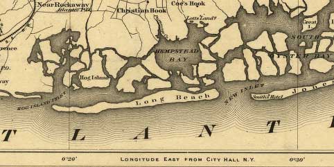
Hog Island (yes, it's in Queens, but it makes a point, and Brooklyn was pretty trashed by the storm too). The 1893 storm, which was a
Category 2, came ashore in Jamaica Bay, near where JFK airport sits today. Some saloons, casinos and resort hotels on a sandy spit of land called Hog Island were completely washed away. A few miles west of the hurricane's eye, almost every building on Coney Island was destroyed. There was extensive flooding in Brooklyn, with water reported as being "waist high" far inland, and wind damage to many of the city's new skyscrapers.
Here's a little description of the storm that was
in a sobering article on "The Big One" that ran in the New York Press a couple of years ago:
On the night of August 23, 1893, a terrifying Category 2 hurricane did strike New York City. It hit land in the marsh that is JFK Airport today and began the erosion of the low-lying resort...All six front-page columns of the August 25, 1893, New York Times were dedicated to the “unexampled fury” of the “West Indian monster.” The storm sunk dozens of boats and killed scores of sailors. Everything below Canal Street was under water. In Central Park, hundreds of trees were uprooted...The brand-new Metropolitan Life building on Madison Avenue was severely damaged when a heavy-iron fence was torn away by the wind, plunging 10 stories and crashing through a stained-glass dome before landing on a mosaic "including quantities of costly Mexican onyx."
A 30-foot storm surge swept across southern Brooklyn and Queens, destroying virtually every man-made structure in its path. In Brooklyn, at Wyckoff and Myrtle Avenues, "the water in the street was up to a man's waist," and residents used ladders to get in and out of their houses. Most of the boats moored at the Williamsburg Yacht Club were "sunk, driven ashore or demolished." The East River rose "until it swept over the sea wall in the Astoria district and submerged the Boulevard." At Coney Island, 30-foot waves swept 200 yards inland, destroying nearly every man-made structure in its path and wrecking the elevated railroad.
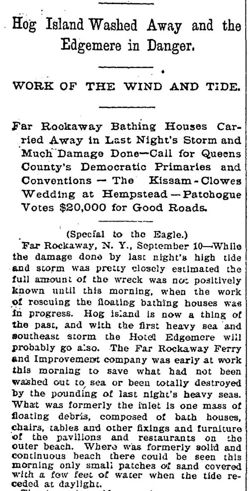
Hog Island was seriously eroded by the West Indian Monster. Then, in 1896, a storm cut a new channel through it. Later in the year, it had been reduced to "small patches of sand covered with a few feet of water when the tide receded at daylight." By 1898,
no more Hog Island.
As for the current day, you can always read one of the annual
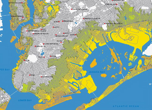
New York City is screwed stories and think about the implications of a storm with 130 mile and hour winds, a 30-foot storm surge, $100 billion in damage and 3 million of us evacuated.
You can check out the Wikipedia article about the hurricane and Hog Island
here. Also, there are numerous articles in the Brooklyn Public Library's
Brooklyn Eagle Archive. That's part of a story from Sept. 10, 1896 below.
Labels: Hurricanes
 Soon, it will be time for an entire new round of stories about how screwed we will all be when a major hurricane hits New York City. (Yes, we said when, not if.) In the meantime, anyone that wants to read how generally screwed Brooklyn and various parts of the city will be in general in future years, should definitely catch up on their reading. Activists in low-lying parts of the borough like Gowanus can take heart, we suppose, that most new developments like the Toll Brothers project and Whole Foods face a very grim future in the long run.--City Limits via Brownstoner