More About Underwater Brooklyn and NYC
 Many times, we've posted different maps of Brooklyn and New York City showing how screwed we are if we're ever hit by a hurricane. We missed a fun Christian Science Monitor article on the subject (but came across it thanks to always excellent and intelligent coverage of streetsblog) that offers wonderful color about what could happen to us and how it will likely happen with greater frequency because of global warming. Here's a sample of the description of the threat:
Feeding off the greater ocean warmth, full-blown hurricanes may arrive at New York City with increasing regularity...By 2050, stronger storms and rising sea levels may make the flood that previously hit once every 100 years a once-in-20-years event, according to GISS. With a possible three-foot sea level rise by 2100, flooding could occur every four years...Some scientists are thinking that barriers, like the ones used to protect parts of the Netherlands and the one being built to save Venice from permanent aqua alta, are the way to go. That's good news for Manhattan and North Brooklyn in 2080 one supposes. :
Sea levels have risen almost a foot in the past century, partly because of ice melt and thermal expansion (warmer water has more volume), and partly because of naturally occurring land subsidence of the Northeast. In the same period, area temperatures have risen nearly 2 degrees F. About two-thirds of that increase occurred in the past 30 years and sea-level rise has accelerated in the past decade. "The core body of knowledge has solidified" on climate change, says Cynthia Rosenzweig, the lead GISS scientist on the climate-change task force. "We're moving into a solution phase."
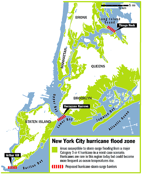
Rather than individually shoring up the city's many vulnerabilities, the better solution is to use the region's topography, say engineer Douglas Hill and Malcolm Bowman, head of the Storm Surge Research Group at Stony Brook University. Three barriers placed at strategic "choke points" - the Verrazano Narrows, Throgs Neck, and the Arthur Kill - would protect all of Manhattan and half the entire flood-prone area, they say.The bad news, of course, is that there's no way to protect the ocean and harbor facing parts of Brooklyn. Bye, bye Coney Island, Sheepshead Bay, etc. etc.
Related Posts:
posted by rsguskind at 8:06 AM
![]()
![]()

0 Comments:
Post a Comment
<< Home