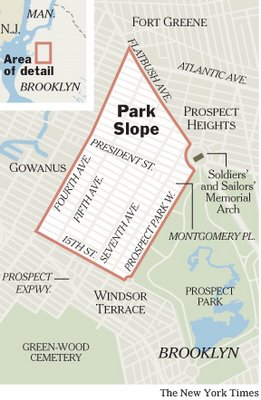
We've been known to say an unkind thing or two about the New York Times' coverage of Brooklyn, most of it having to do with the way the most important paper in the nation covers our borough infrequently and incompletely. A lot of Brooklyn news, unfortunately, does not appear fit to print. In any case, the Times ran
an article about Park Slope in the Real Estate Section and a reader emailed us to note that the paper ran a map that actually got the neighborhood's borders right, by 2000s standards. Meaning that
it doesn't try to usurp any of Gowanus or Sunset Park. (We wouldn't have looked at the map on our own, as we know where Park Slope is, so we thank the eagle-eyed GL reader for pointing it out.) In any case, here are few words from the article about Fourth Avenue:
These days it’s also a construction zone, at least on its fringes. Developers have worked quickly since 2003 zoning changes along Fourth Avenue, Park Slope’s noisy, truck-filled western border with Gowanus, to begin building condominium towers and a hotel there. Comparisons to a new Park Avenue for Brooklyn are being made, with occasional snickers, on local blogs. But building presses on, with sales soon to begin at the Novo Park Slope, a wide 12-story condo building at Fifth Street. The construction is “very quickly transforming Fourth Avenue from what was otherwise a forlorn, neglected thoroughfare into a place where people can live,” said Craig Hammerman, district manager for Community Board Six. “Whether or not the infrastructure is there to support it is now the newest challenge.”
We now return to our regular programming, grousing about how the Times is more likely to report on a Brooklyn stabbing than an important development or public policy issue issue.
 We've been known to say an unkind thing or two about the New York Times' coverage of Brooklyn, most of it having to do with the way the most important paper in the nation covers our borough infrequently and incompletely. A lot of Brooklyn news, unfortunately, does not appear fit to print. In any case, the Times ran an article about Park Slope in the Real Estate Section and a reader emailed us to note that the paper ran a map that actually got the neighborhood's borders right, by 2000s standards. Meaning that it doesn't try to usurp any of Gowanus or Sunset Park. (We wouldn't have looked at the map on our own, as we know where Park Slope is, so we thank the eagle-eyed GL reader for pointing it out.) In any case, here are few words from the article about Fourth Avenue:
2 Comments:
Well, they were close to the right border. 15th Street is merely a governmental boundary between community boards. It seems ridiculous to me to say that folks on one side of 15th St are in park slope and right across the street they are in Sunset Park (or Greenwood Heights). The Prospect Expressway, just a few more blocks south is the traditional border because it creates a huge gap between the neighborhoods.
I'm less inclined to argue this point than I was in the past, but i'm open to debate thru email - tony churchroad@gmail.com
I also was always under the impression that the Park Slope borders were Prospect Expressway as well as 3rd Avenue. I live on 15th between 3rd and 4th and have the 11215 zip code...
Post a Comment
<< Home