Stormy Weather Part II: Brooklyn Waterworld Maps
As we spent yesterday looking out the window at the deluge--dismissing taking the camera down to Coney Island to shoot high water and wind or to search for a Gowanus Sewage Geyser (you have pics of either, email them to us and you will earn our undying gratitude)--our minds turned to the possibility of massive flooding in Brooklyn during a monster storm. No one knows when it will happen, except that it will happen and that the odds are increasing.
For a weird take on the ultimately watery fate of many Brooklyn neighborhoods, check out this article in the Brooklyn Rail. It has a good rundown of the possibilities, along with a bonus in the form of fascinating commentary from a real estate agent on Bedford Avenue:
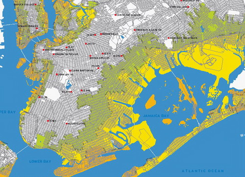
We have zero influence on what’s going to happen. Take the Tsunami. Bad people live over there. Like, people in New Orleans were punished for all the prostitution, the gays and the lesbians. God doesn’t like that. So if the flood is going to come, it’s not from what we do.Half of Brooklyn gets swamped in a Category Three hurricane, so we figured it useful to capture some images from the Hurricanes and NYC brochure produced by the Office of Emergency Management. (You can check out what should be in your Go Bag here.)
Note how especially screwed Williamsburg, Greenpoint, Gowanus, Red Hook and, of course, Coney Island are. Orange, by the way, is flooding in a Category One storm. Yellow is a Category Two and Green is a Category Three.
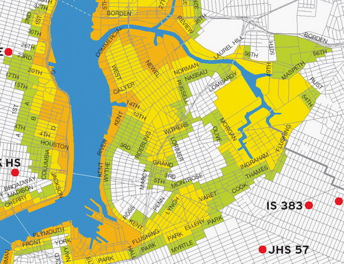
North Brooklyn Gloom--Williamsburg & Greenpoint Underwater
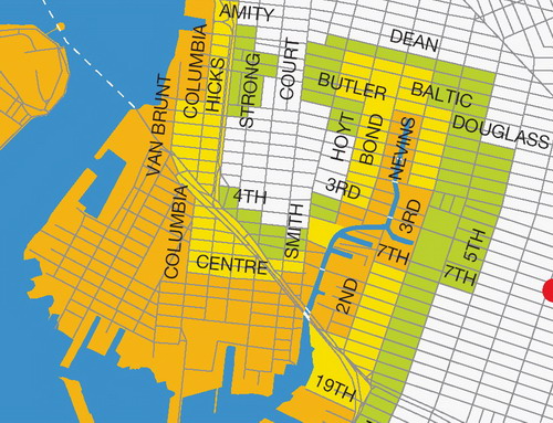
Gowanus and Red Hook Gloom--Very watery
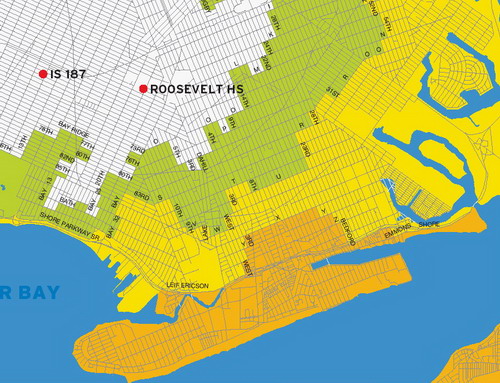
Coney Island Coastal Gloom--Note how far inland water could reach
Related Posts:
The Amazing Underwater Borough
Ever Hear About Hog Island?
Labels: Preparedness, Storms
posted by rsguskind at 7:55 AM
![]()
![]()

5 Comments:
Well, the good news is that maybe this will prevent some people from buying property in these areas, and/or drive the property values (and therefore our rent) down a bit (or at least keep prices stable). Every time some developer or enterprising yuppie mentions something about buying along the Brooklyn waterfront, you should whip out this map.
I am confused. Half my block is green - and the other half is...white! Silly me for not buying across the street.
i realize they are drawing boundary lines alone streets and not mid-block but i find it hard to believe water would come all the way up to 5th avenue around president & carroll street as they have quite a slope each (probably at least 1-2 stories).
While the City is out supposedly warning those in the orange/yellow/green areas of the risks...yet the same City and State is allowing even pushing for more mega deveolpment on the waterfront- Williamsburg/Greenpoint and RedHook...How is the City allowed to do the later when it conflicts with the former? Is NYC betting the Federal Gov will bail out all those new yuppie condo buyers? I don't think people in Ohio are gonna want to subsidize these jerks who ignored the Cat risk, the Toxic risk etc... The Insurance Industry is overtly getting out of there exposures NOT just increasing premiums...Obviously they are taking it seriously and they have the most info on the topic, so when the most informed market participant is effectively "selling" what should that be telling you? Hope those new yuppie suits from Manhattan who think living in BK is edgy or that prices will continue to skyrocket (LOL) get up to speed on what its like to try and rebuild a condo where everyone is at odds with everyone else as no one has cover....Yeah , have fun yupsters.
You know there is a reason why the UES and UWS are where they are....right people 100+ years ago built their homes where it was the safest best land...duh...and Greenpoint was a swamp as was alot of Williamsburg...good for indutrial ...and that's what they have been for decades.....Are youn corp suits in Manhattan drinking the RE agents coolaid?
If there is a hurricane in Williamsburg/Greenpoint even just a Cat 1 ...as you reference the low flood areas mirror the historic path of Newton Creek...and as GL has pointed out elsewhere, in its coverage of the oil spills in Williamsburg, may have migrated over time to other parts of williamsburg through the underground spring system here...it makes one wonder what will happen if hurrican flooding accentuates the distribution more widely of those oil spills....It seems to me that there is a very large containmation problem that could be maginified significantly by a bad storm...and seems like no way to contain it....What will property owners do who suddenly find that their ground has become contaminated??? What legal recourse will they have? Who could thy sue? Really no one yet their property value will go down....and you can see why insurers would be even doubly nervous about insuring real estate in Williamsburg/Greenpoint.
Post a Comment
<< Home